
Is Iran using China’s BeiDou system to launch ‘accurate’ missile strikes?


The ongoing conflict in West Asia has raised new questions about the technology behind Iran’s missile strikes. Intelligence analysts now believe Tehran may be using China’s satellite navigation network to guide some of its weapons with greater precision.An Al Jazeera suggests that Iran’s targeting accuracy has improved noticeably during the latest round of fighting with Israel and the United States. That has led to speculation that Iran could be relying on the BeiDou Navigation Satellite System, China’s global satellite positioning network designed to rival the US-run Global Positioning System.
China’s rival to GPS
The BeiDou Navigation Satellite System is China’s independently developed satellite navigation network that provides positioning, navigation and timing services worldwide. The system was officially completed in 2020 and launched as a global service during a ceremony overseen by Chinese President Xi Jinping in Beijing.China began developing its own satellite navigation capability in the late 1990s after the Third Taiwan Strait Crisis raised concerns that Washington could restrict access to GPS during geopolitical tensions. Beijing’s goal was to create a system that could operate independently of US-controlled infrastructure.
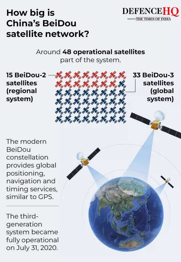
BeiDou was built in three stages. The first generation provided limited services within China by 2000. A second phase expanded coverage across the Asia-Pacific region by 2012. The current third generation—known as BDS-3—now provides global coverage.Like other navigation systems, BeiDou calculates a user’s location by transmitting signals from satellites to receivers on Earth. By measuring the time it takes signals from several satellites to arrive, the receiver can determine its exact geographic position.The system’s architecture includes three components: a space segment made up of satellites in different Earth orbits, a ground segment consisting of control and monitoring stations, and a user segment that includes receivers, chips, antennas and navigation services.China says the network supports a wide range of civilian activities including transportation, agriculture, disaster relief and telecommunications. At the same time, like GPS and other navigation systems, it can also support military applications such as missile guidance.
Why analysts think Iran may be using it
Some analysts believe Iran has been gradually integrating BeiDou into its military systems for years. Researcher Theo Nencini has said Iran reportedly signed an agreement in 2015 to integrate an earlier version of the system into its infrastructure.The process appears to have accelerated after the 2021 strategic partnership agreement between China and Iran. According to experts cited by Al Jazeera, the Iranian military began incorporating BeiDou signals into missile and drone guidance systems as well as secure communications networks.
Iran’s Ministry of Information and Communications Technology has said the country uses “all existing capacities in the world” rather than relying on a single navigation source. Analysts therefore believe Tehran may combine multiple systems, including GPS, Russia’s GLONASS and Europe’s Galileo (satellite navigation system).However, the latest conflict appears to have accelerated the shift. During the brief but intense war with Israel last year, GPS signals in parts of the region were reportedly disrupted. That experience may have pushed Iran to rely more heavily on alternative systems.
How satellite navigation improves missile accuracy
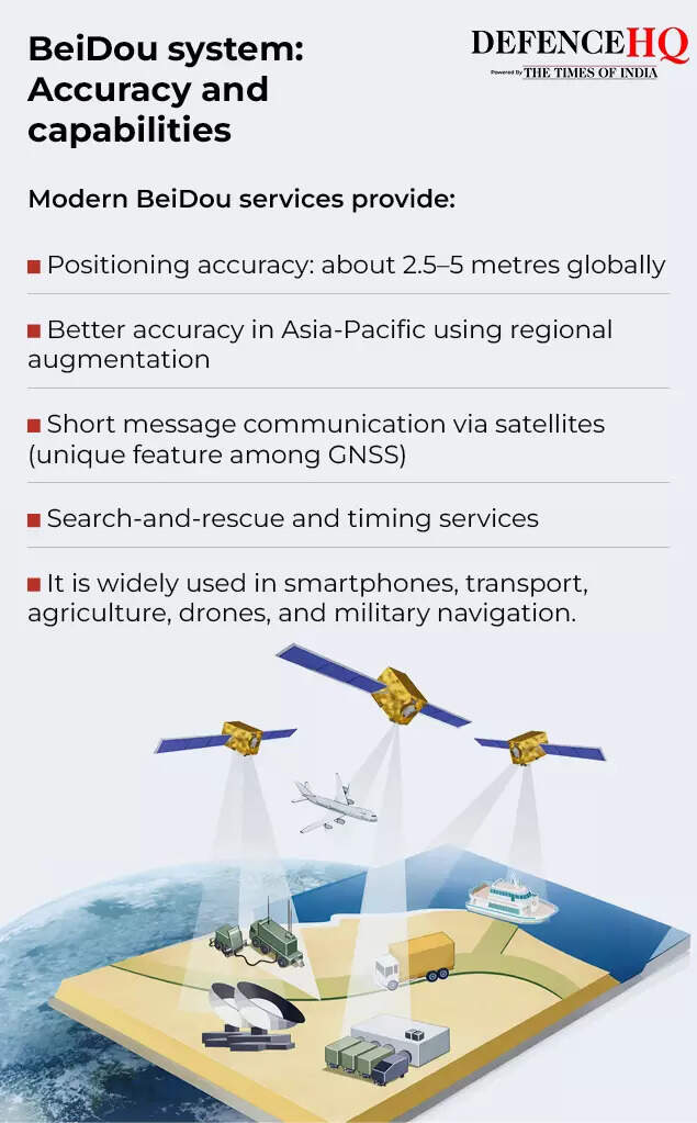
Missiles typically rely on inertial navigation systems, which track motion using internal sensors such as gyroscopes and accelerometers. While reliable, these systems gradually accumulate errors over long distances.Satellite navigation helps correct those errors.By combining inertial navigation with satellite signals, a missile can constantly update its position and refine its trajectory. This dramatically improves targeting precision.Analysts say BeiDou could also help Iranian weapons overcome electronic warfare measures. Western forces often attempt to jam or spoof GPS signals by broadcasting false coordinates. Advanced signals from BeiDou are designed to resist such interference through encrypted transmissions and authentication systems.
A wider shift in modern warfare
If Iran is indeed using BeiDou for military guidance, experts say it could signal a broader shift in the balance of technological power.For decades, the United States’ GPS network dominated global navigation and precision-strike capabilities. But the expansion of alternative systems—China’s BeiDou, Russia’s GLONASS and Europe’s Galileo—means countries now have multiple navigation sources.Analysts say access to these systems reduces reliance on US technology and makes it harder for adversaries to disable navigation signals during conflicts.The ongoing war in West Asia has already seen Iranian missiles and drones targeting Israeli and US-linked sites across the region. As long-range weapons become more accurate and resistant to electronic interference, satellite navigation systems such as BeiDou are likely to play an increasingly important role in future conflicts.